


Factors Affecting Settlement Location
- Water supply: a close supply of fresh water was vital for drinking, cooking and washing.
- Building materials: wood & stone were essential building materials. Their weight meant that people didn't want to move them too far.
- Dry point: the site of the settlement needed to be dry to ensure stable land and to reduce the spread of disease through stagnant water.
- Flat land: this makes building, transporting materials and farming the land much easier than if the land is sloped.
- Fertile land: important for growing crops to support an increasing population.
- Bridging point: settlements were often established at points at which rivers could be crossed. These were important trade routes and provided defence.
- Defence: historically cities needed to protect themselves from other tribes and invasions. Sites that had good views, strategic rivers were popular.
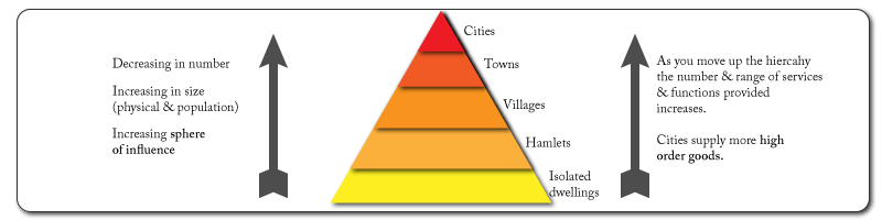
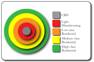
Concentric Ring model
- Designed by Burgess in 1924
- Based on the city of Chicago.
- Based on the concept that as the settlement grows the housing and environment improves.
- This creates zones spreading out from the center.
- Assumes an isotropic plane (that land & resources are equal in all directions), which in reality is often not the case.
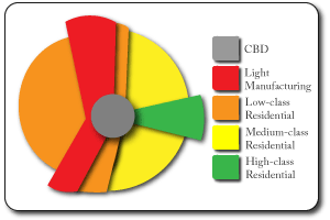
Hoyt Sector Model
- This model built on the concentric ring model to take into account the effect of transport routes.
- Industry often locates along transport routes (it needs delivery of raw materials & the ability to transport the finished goods.
- The low class residentail sector is linked to the manufacturing zone as it provides the workers ( these areas are likely to be noisey and have higher pollution rates from the industries).
Urbanisation
Urbanisation: an increase in the % or proportion of the population living in towns and cities.
This process happened in MEDCs as they industrialised but is now more commonly associated with LEDCs. The main causes are:
Push Factors of rural areas
- Mechanisation of agriculture is leading to significant reductions in the workforce needed.
- Lack of quality secondary education and higher education services.
- Poor service provision and infrastructure (internet, cell-phone, piped water, reliable electricity).
Pull Factors of urban areas
- Range of entertainment & leisure services (restaurants, cinemas, shopping malls, nightclubs etc).
- Universities, colleges, main hospitals.
- Range of job opportunities (IT, banking, politics, office jobs) & higher wages.
Whilst these are certainly all available in cities the ability of inward migrants to access them may be very limited.
Counter Urbanisation
- This is the movement of people out of the cities to live in the surrounding areas.
- Traffic congestion, lack of space, noise, higher crime rates and the movement of many jobs out of the CBD are pushing people out..
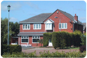
- Rural areas and surrounding villages offer more pleasant environments, larger houses with gardens. Out of towwn supermarkets and retail parks mean that they are still close to facilites. Many people now work from home.
Decentralisation
- This is the movement of shops & businesses out of the centre of urban areas to the edges.
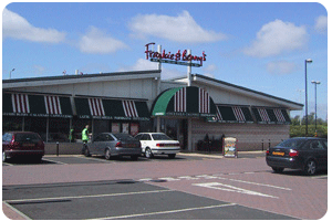
- Traffic congestion, lack of parking space, high land values, lack of room for expansion are pushing firms out..
- The internet & ICT development have meant that firms don't need to be close to other services. More rural locations offer better working environments for many tertiary industries.
- Room for expansion, ample parking and more sub-urban workforces attract firms to out of town locations
Case Studies
MEDC Regeneration
Location: Greenwich Peninsular, London, UK
Cause: Old dock based industrial inner city area of London. Industry had closed, buildings were derelict & few job opportunities.
Effects:
- Old industry cleared & a community created (housing, health & leisure centres.
- 2 schools, supermarket & cinema).
- O2 Dome built, major concert hall & exhibition centre.
Aimed at being sustainable:
- Recycled materials
- Energy saving houses.
- Wind & solar power used in supermarket.
- Underground link (tube train), cycle paths & good bus links to area to reduce need for cars.
LEDC Urban Growth
Location: Cairo, Egypt
Cause: Rapid population growth –rural to urban migration. 13 + million people.
Effects:
- Housing shortages, 80% of people living in self built shanty houses.
- People living in tombs (City of Dead).
- Traffic congestion & air pollution.
- Lack of jobs & jobs often poorly paid.
- Water pollution: ground water & the Nile.
Solutions:
- New towns being built outside Cairo to accommodate people & provide jobs (10th Ramadan City).
- Metro line (underground train) has been built, limited lines currently but 1 million commuters/day.
- Improved sewers and rubbish collection services.
- Large ring road built around the city.