


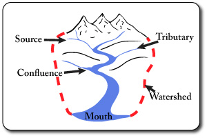
Drainage Basin Features
- Source: start of the river ( there may be many).
- Tributary: a smaller river that joins a larger one..
- Confluence: the joining of a tributary to the larger channel..
- Mouth: the end of the river, where it meets the sea.
- Watershed: the outer limit of the drainage basin.
- Drainage Basin: the total area drained by a river system.
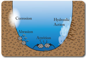
Erosion Processes
- Hydraulic Action: pressure/force of the water loosening material & widening cracks in the river bank.
- Abrasion: the scraping action of material being transported.
- Attrition: the breaking of stones when they collide with other material.
- Corrosion: the dissolving of rock (limestone etc) by acid in the water.
- Erosion occurs more in the upper course than the lower course.
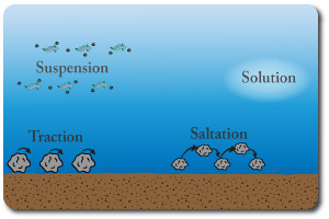
Transportation Processes
- Traction: the rolling of stones & rocks. Usually larger rocks.
- Saltation: stones/rocks bouncing. Usually smaller rocks due to the energy required.
- Suspension: very small particles being carried along in the river current.
- Solution: dissolved material (invisible).
- Traction & saltation occur more in the upper sections of a river.
Deposition Processes
- Deltas: these form at the mouth of the river due deposition of material. The main channel splits into many smaller distributaries.
- Levees: Natural embankments that form alomg the river in the lower course. caused by the deposition of heavy material in floods..
- Braided Channels: The splitting of the river into different channels which then come back together (islands in the river).
- Floodplains: large, flat & fertile areas by the side of a river in the lower course, caused by deposition of soil/silt in times of flood.
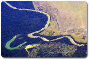
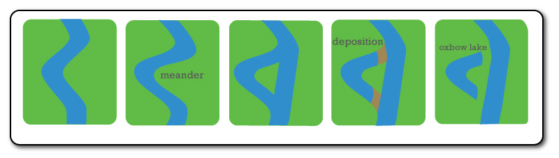
Meanders & Oxbow Lakes
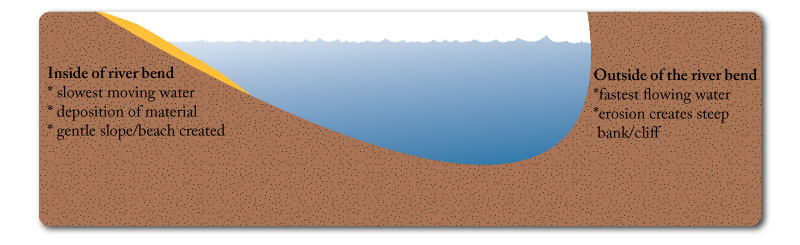
- The water flows the fastest around the outside of a river bend. This erodes it and widens the bend.
- On the inside of the bend the water is travelling slowly and this leads to deposition.
- This widening of the bend continues creating meanders.
- Eventually two of the meanders may get so wide that they join up, when this occurs the river takes the shortest route and the meander becomes cut-off. This is an oxbow lake.
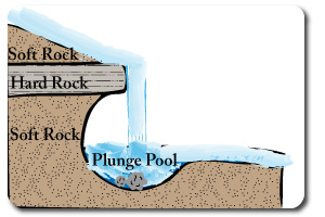
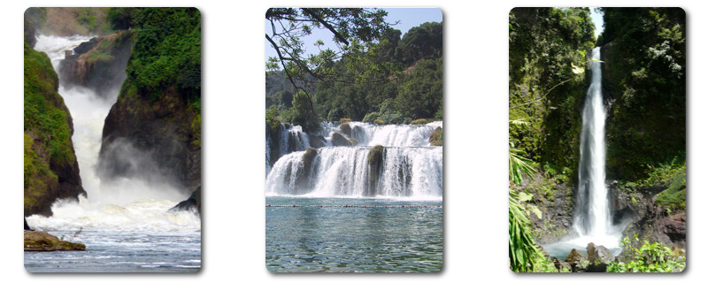
Waterfalls
- Occur when rivers flow over layers of soft & hard rock.
- The soft rock is eroded more easily, this leads to the hard rock being undercut.
- A ledge of hard rock forms unitl it breaks and collapses into the plunge pool. Each time this happens the waterfall moves further upstream.
- As the waterfall retreats upstream it often creates a gorge.
- Waterfalls occur in the upper and middle courses of rivers.
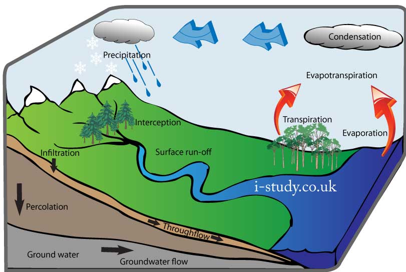
Heavy Rainfall: the rainfal exceeds the grounds capacity to absorb it causing large amounts of surface runoff.
Prolonged rainfall: this causes the ground to become saturated and additional water has to runoff rather than soaking in.
Urbanisation: urban areas create impermeable surfaces and channel water quickly to rivers.
Deforestation: Trees intercept rainfall, soak up water from the soil and reduce soil erosion. deforestation leads to increases in surface run off and soil erosion.
Silting: this is the depostion of silt (mud) in river channels which reduces its capacity for carryig water. Soil erosion in the upper course of a river (due to deforestation and farming often) can increase solting in the lower course.
Impermeable surfaces: impermeable soils such as clay and exposed rock layers stop water soaking in and lead to larger volumes entering the river.
Loss of life & injury, this also puts extra pressure on emergency services to rescue and treat people before infection takes hold.
Building damage: loss of homes leads to major social problems as peopl need to find shelter. Damage to businesses can severely affect the economy. Damage to hospitals and schools affects the services provided.
Crop & livestock loss: this can very damaging impacts as food shortages may occur for the rest of the year and rising food prices will hot the poorest the most.
Fresh water contamination: this can cause rapid spread of disease (cholera & typhoid) and is a major concern for flooded areas.
Infrastructure: disruption to communication, power, and road networks makes evacuation and search and rescue much more difficult.
Afforestation: planting trees can stabalise soils, reduce surface run-off and soak up water from the ground.
Dredging rivers: this eliminates the effect of silting by scooping out the deposited material with a boat.
Dams: dams in the upper courses of rivers can regulate the flow and hold back water in times of flood risk.
Embankments: artificial embankments and levees can be used to raise the sides of a river bank to allow it to hold more water.
Warning systems: these can allow the evacuation of people downstream and avoid some of the effects of a flood.