Urbanisation
Definition: An increasing percentage of a country’s population comes to live in towns and cities. It may involve both rural–urban migration and natural increase.
Urbanisation is occuring most rapidly in developing countries.
The fastest growing cities are in Asian, African and Latin American countries. These regions have been experiencing high population growth rates and large scale movements of people to cities seeking better economic opportunitites.
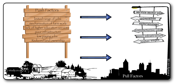
Rural to Urban Migration
Centripetal (inward) movements occur when people move from rural areas to urban areas
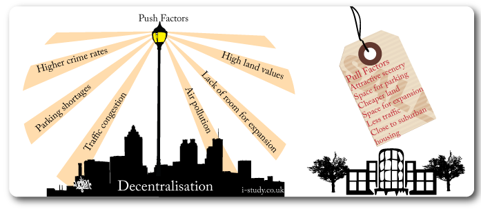
Push factors are the negative aspects about a place/location that cause people to leave.
Pull factors are the positive factors about places that attract people to them.
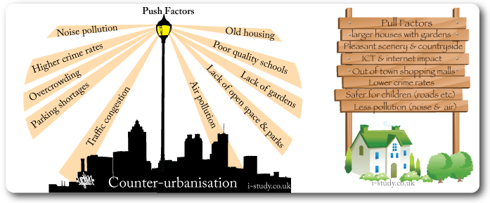
Counter-Urbanisation
Definition: The movement of population away from inner urban areas to a new town, a new estate, a commuter town or a village on the edge or just beyond the city limits/rural–urban fringe.
Counter-urbanisation is resulting in cities becoming more expansive. You should know these two terms:
Suburbanisation: The growth of towns & cities to include (engulf) surrounding villages/ rural areas.
Urban Sprawl: Unplanned & uncontrolled spread/growth of a city into the surrounding rural area.
Decentralisation
Definition: The movement of shops, offices and industry from urban centers edge of town or rural locations.
The decentralisation of offices and retailing due to the factors shown in figure G4 contributes to counter-urbanisation.
As workplaces and services become located on the egde of towns, it makes more sense for people to live in the suburbs/satelite villages. High car ownership and ring roads make commuting to these locations relatively quick and easy.
Megacities
Defintion: cities with a population over 10 million
Objective: Explain the global increase in the number and location of megacities
Tasks
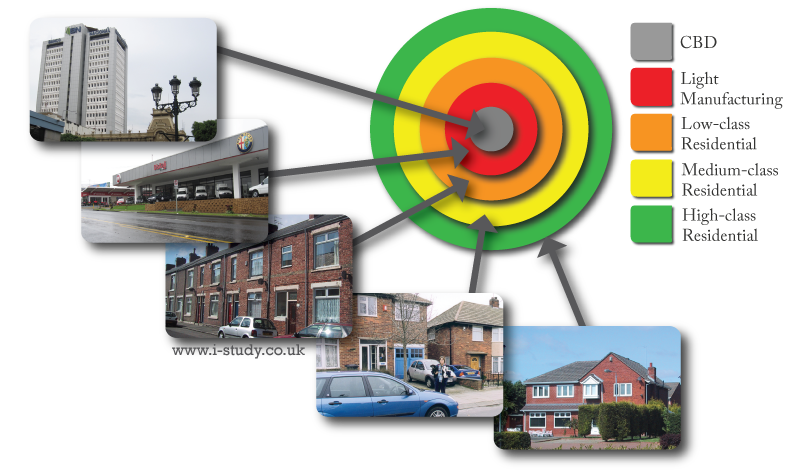
Concentric Ring Model; Burgess
Quick summary
This model dates back to the 1960s and was based on Chicago.
CBD: the oldest and central part of the city. It is the most accessible part of the city- transport routes lead inwards to it. It is home to the main retail, banking and office buildings (many shops have offices above them on the higher floors). See figure G for more detail about the CBD.
During industrialisation and the rapid inward migration of people looking for work the city expanded and industry located around the CBD. In many developed countries the original heavier industry has been replaced with light manufacturing and distribution firms.
The workforce employed in the industries lived close by, in generally high density cheaper housing (flats or terraced streets)
Over time and with growing affluence the city expands. Larger houses with gardes and drives for cars are built around the existing housing forming the suburbs - residents are generally slightly wealthier and likely to own a car.
The wealthier residents live on the outskirts of the city in large detached houses close to the countryside
Limitations
Sector Model; Hoyt
This model introduced the idea that lines of transportation would have a significant impact on land-use zoning.
Industry is likely to locate along routes of transportation (road and rail) to receive raw materials and to deliver the final product.
Workers in these industries were likely to live close the industries (lack of transport and perhaps accomodation provided by the industries).

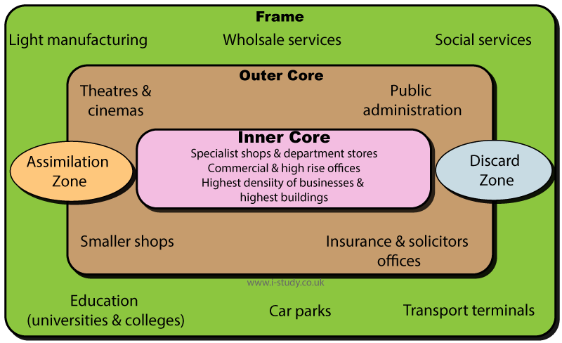
CBD Core & Frame
Brownfield Land
Definition: Abandoned, derelict or under‑used industrial buildings and land that may be contaminated but have potential for redevelopment.
Tasks
Read factfile - UK brownfield sites
Why are brownfield sites often more expensive to develop than greenfield land?
UK brownfield development issues (2001)
Example 1:London Olympic Park
Read the following articles and make notes about the site of the olympic park - where, clean-up required, benfits to the area: pdf article, olympic site.
Example 2: Battersea Powerstation, London
Read this Guardian article and watch the video opposite, make short notes about what the original use was and the new land use due to redevelopment.
What are the concerns about the redevelopment of the powerstation?
Formal Job Sector
This is the official sector of employment. Workers benefit from regulated hours, holidays and sick pay. They contribute to state pensions and benefit from social security policies.
Working in the formal sector makes it much easier to secure bank loans (buy cars, houses, start businesses etc).
The formal sector is more difficult to enter - workers usually need evidence of education or qualifications and a recognised permanent address. A bank account is also neccessary for getting paid in most cases.
Informal Job Sector
This is the unofficial sector, is wide ranging and plays an important role in many urban areas.
The formal sector lacks the financial security of the formal sector, is unregulated in terms of working conditions and safety. Workers in this sector dont contribute to state schemes such as pensions and health care.
Despite the risks of being employed in the informal sector it provides much needed opportunity for many of the poorest residents, especially those in slums/favelas.
In LEDCs the informal sector plays a vital role in recycling waste material and reducing the waste going to landfill sites.
Read this article

Urban Heat Islands
You should be able to explain the causes of higher temperatures and modified local climatic features in urban areas.
Factors such as the change in the albedo rate due to roads and buildings, the heat released from transport, the leakage of heat from buildings (heating and air conditioning).
Other factors to consider are things such as changes in the levels of humidity due to the loss of vegetation and the rapid draining of surface water out of the area. Changes in wind speed and flow due to building design (Chicago is a good example).
Tasks
Urban Stress
Urban areas suffer from pressure due to their nature of dense populations.
Guardian 2015 article looking at the patterns of use and urban stresses for 4 major global cities. Some good information about comparative densities and transport networks.
You should be able to describe and explain examples of urban stress, supporting your answers with examples.
Use the videos and links to make case study notes.
Urban waste disposal tasks
Air Pollution: London, UK
Air pollution from industry and traffic is a major issue in many urban areas. Diesel vehicles emmit nitrogen dioxide which is known as the silent killer as it penetrates deep into the lungs and blood stream. It is known to causes cancers and respiratory diseases. Traffic congestion in cities results in high levels of nitrogen dioxide being released as buses, lorries, vans and cars clog the streets.
MEDCs have high car ownership and traffic congestion which results in many European cities failing to meet the European Union air quality regulations. Vehicles are often newer, more efficient and less polluting in MEDCs.
Developing countries have less vehicles/capita, but they are often older and more polluting. Rapid increases in car ownership have resulted in major traffic congestion and high levels of air pollution.
Protecting the environment, Tfl
Tasks
Housing quality & crime: Rio de Janeiro, Brazil
Rapid inward migration has led to housing shortages and the emergence of favelas (slums). These are areas of illegally built poor quality housing with little of no infrastructure.
Lack of sanitation, public services such as health and education facilities, electricity and tapped water lead to many social problems.
Rocinha is one of the oldest and largest favelas and has experienced improving conditions over the last decade.
Tasks
Use the link above to answer the following;
Solving Rio de Janiero housing problems
The rapid inward migration to Rio has resulted in many favelas (slums). A lack of available housing and the relative poverty of the migrants arriving have meant that authorities have to try different methods to deal with the problem:
Sustainable City Index
Cities around the globe in both developing and developed countries are facing many challenges due to their size and the resources that they consume.
Their populations are increasingly aware of the health issues caused by pollution (water, air and and noise). International agreements have been established to reduce different types of pollution and fines for failure may be imposed. Traffic congestion, over-crowding ,poverty and crime are examples of social issues that need to be addressed to improve the functioning of urban areas.
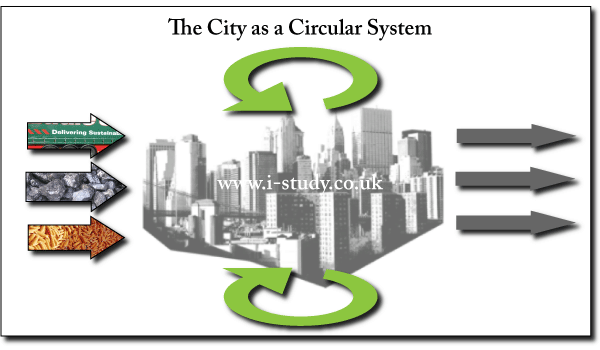
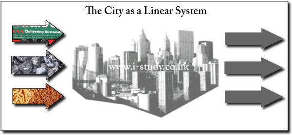
Linear Systems
inputs—energy, water, people, materials, products, food
outputs—solid, atmospheric and liquid waste, noise, people.
Inputs are consumed and waste sent for disposal, ususally in landfill or incineration.
Circular Systems
Reducing, reusing and recycling the resources that the city consumes lead to less inputs and less outputs, shrinking their urban ecological footprint and increasing their sustainability.
This circular approach can be applied by households, industry and local governments/councils.
Be able to discuss strategies and impacts with examples.